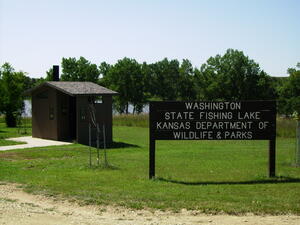
Washington State Fishing Lake


Washington State Fishing Lake and Wildlife Area is located 12 miles northwest of Washington, a short distance from the Nebraska border. The 65-acre lake in surrounded by 352 acres of public hunting land that harbors quail, pheasant, dove, squirrels, rabbits, white-tailed deer, turkey, beaver, muskrats, raccoons, coyotes, bobcats and numerous nongame birds and animals. The lake also serves as a stopover area for migrating waterfowl in the fall and spring. Several food plots are maintained each year to provide winter food for birds and other wildlife.
The lake has been stocked with several species of fish including: largemouth bass, walleye, saugeye, channel and flathead catfish, bluegill and crappie. Test nettings are performed annually to monitor the fish population and supplemental stockings are made when necessary.
The lake and wildlife area are open year round. Picnic tables, fireplace grills and primitive camping areas are available for public use.
Manager: Keaton McGuire
Phone: 785-461-5402
Assistant Manager:
Lake News
Dam Maintenance:
Trees have been removed from the dam the past few years and more trees will continue to be removed until the dam is free of all brush. Broad leaf herbicides have also been sprayed to reduce unwanted trees and brush on the dam itself. The presence of brush on the dam negatively affects the integrity of the dam and we must remove the brush to stay in compliance with our dam maintenance guidelines.
Camping information:
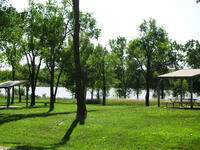
Washington State Fishing Lake offers numerous camping areas along the east side of the lake. There are several picnic shelters, yard lights, fire rings, boat ramp and a vault toilet. There is no running/potable water or electrical outlets on the area. Camping is free of charge and no reservations are needed. There is a 14 day limit to camping on the area. A valid Kansas fishing license is needed to fish the lake and boats are allowed for fishing or hunting purposes only.
Dam Structure Has Been Repaired: March 2013
New slats have been installed on the water structure located on the dam. The water level in the lake will now be able raise approximately 4 feet from it's current level providing we receive adequate rainfall. Various fish species may be stocked in the future as they become available.
Campground Update:
Fishing and hunting regulations are posted on the information kiosks. Lake maps and hunting/fishing regulation pamphlets are also available at the kiosks. The roads are graded at least twice a year, usually before Memorial Day and Labor Day weekends.
Wildlife Area:
Prescribed Fire
A growing season burn was conducted in late July 2018 on approximately 80 acres south of the main entrance. Growing season burns are intended to help reduce woody encroachment, temporarily reduce grass competition and increase forbs (wildflowers) within the native grass stands.
A growing season burn was conducted in late August 2017 on approximately 27 acres north of the main entrance.
Woody Vegetation Removal
A small amount of tree shearing was done in the winter of 2019 on native grass areas near the dam to reduce some of the tree invasion in the native grass areas. Some trees were also removed within and around the campground areas as well. Other areas of brush were mulched and sprayed to provide more lake shore access. More tree shearing will be conducted as time and budget permits.
- Off Road Vehicle and Horse use is prohibited.
- Trotlines and setlines are not allowed on state fishing lakes.
- Motor boats may be used for fishing and hunting purposes only on state fishing lakes.
Special Features: Special provisions are available for handicapped persons. Please call the Milford Wildlife Office at (785) 461-5402 for more information.
Here is a complete list of Public Land Regulations or you can download the regulation summary.
The lake was initially constructed and stocked in 1958. The lake was rehabilitated and restocked in 1975. A silt catching and settling basin was created in 1977 by constructing a dike across the upper third portion of the lake and lowering the water level five feet.
- Type of Facility: Boat Ramp
- Location of Facility: N39 55.674 W97 07.088
- Click for more information
- Type of Facility: Vault Toilet
- This facility is ADA accessible
- Location of Facility: N38 53.960 W96 52.234
- Click for more information
- Type of Facility: Entrance
- Location of Facility: N39 55.793 W97 07.077
- Click for more information
- Type of Facility: Parking Area
- Location of Facility: N39 55.514 W97 06.975
- Click for more information
- Type of Facility: Food Plot
- Location of Facility: N39 55.534 W97 06.956
- Type of Facility: Food Plot
- Location of Facility: N39 55.861 W97 07.452
- Type of Facility: Food Plot
- Location of Facility: N39 55.909 W97 07.410
- Type of Facility: Food Plot
- Location of Facility: N39 55.960 W97 07.148
- Type of Facility: Food Plot
- Location of Facility: N39 55.978 W97 07.017
- Type of Facility: Food Plot
- Location of Facility: N39 56.000 W97 06.963
- Type of Facility: Food Plot
- Location of Facility: N39 56.022 W97 07.195
- Type of Facility: Food Plot
- Location of Facility: N39 56.137 W97 07.256
- Type of Facility: Food Plot
- Location of Facility: N39 56.213 W97 07.281
- Type of Facility: Food Plot
- Location of Facility: N39 56.238 W97 07.262
- Type of Facility: Food Plot
- Location of Facility: N39 56.308 W97 07.325
- Type of Facility: Food Plot
- Location of Facility: N39 56.308 W97 07.325
- Type of Facility: Entrance
- Location of Facility: N39 55.151 W97 07.505


